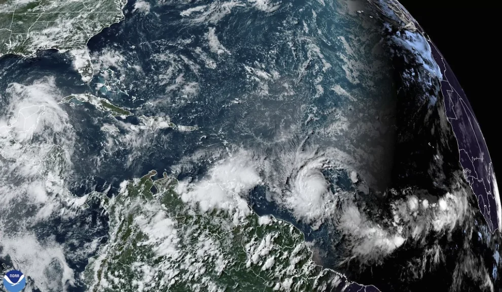
SAN JUAN, Puerto Rico (AP) — Beryl strengthened into a hurricane Saturday as it churned toward the southeastern Caribbean, with forecasters warning it was expected to become a dangerous major storm before reaching Barbados late Sunday or early Monday.
A major hurricane is considered Category 3 or higher, with winds of at least 111 mph (178 kph). At midafternoon Saturday, Beryl was a Category 1 hurricane, marking the farthest east that a hurricane formed in the tropical Atlantic in June, breaking a record set in 1933, according to Philip Klotzbach, Colorado State University hurricane researcher.
A hurricane warning was issued for Barbados, and a hurricane watch was in effect for St. Lucia, Grenada, and St. Vincent and the Grenadines. A tropical storm watch was issued for Martinique, Dominica and Tobago.
“It’s astonishing to see a forecast for a major (Category 3+) hurricane in June anywhere in the Atlantic, let alone this far east in the deep tropics. #Beryl organizing in a hurry over the warmest waters ever recorded for late June,” Florida-based hurricane expert Michael Lowry posted on X.
Beryl’s center was forecast to pass about 26 miles (45 kilometers) south of Barbados, said Sabu Best, director of the island’s meteorological service. Forecasters then expected the storm to cross the Caribbean on a path toward Jamaica and eventually Mexico.
Late Saturday afternoon, Beryl was centered about 720 miles (1,160 kilometers) east-southeast of Barbados, with maximum sustained winds of 75 mph (120 kph). It was moving west at 22 mph (35 kph).
“Rapid strengthening is now forecast,” the Miami-based U.S. National Hurricane Center said.

Atmospheric science researcher Tomer Burg noted that Beryl was just a tropical depression with 35 mph winds Friday.
“This means that according to preliminary data, Beryl already met rapid intensification criteria before even becoming a hurricane,” he wrote on the social media platform X.
Warm waters were fueling Beryl, with ocean heat content in the deep Atlantic the highest on record for this time of year, according to Brian McNoldy, University of Miami tropical meteorology researcher.
Beryl also is the strongest June tropical storm on record that far east in the tropical Atlantic, according to Klotzbach.
“We need to be ready,” Barbadian Prime Minister Mia Mottley said in a public address late Friday. “You and I know when these things happen, it is better to plan for the worst and pray for the best.”
She noted that thousands of people are in Barbados for the Twenty20 World Cup cricket final, with India beating South Africa on Saturday in the capital of Bridgetown. It is considered cricket’s biggest event.
Some fans, like Shashank Musku, a 33-year-old physician who lives in Pittsburgh, were rushing to change their flights to leave before the storm.
Musku said by phone that he has never experienced a hurricane: “I don’t plan on being in one, either.”
He and his wife, who were rooting for India, found out about Beryl thanks to a taxi driver who mentioned the storm.
St. Vincent and the Grenadines Prime Minister Ralph Gonsalves said in a public address Saturday that shelters would open Sunday evening and he urged people to prepare. He ordered officials to refuel government vehicles and asked grocery stores and gas stations to stay open later before the storm.
“There will be such a rush … if you keep limited hours,” he said as he apologized ahead of time for government interruptions on radio stations with storm updates. “Cricket lovers have to bear with us that we’ll have to give information … this is life and death.”
Beryl is the second named storm in what is predicted to be a busy hurricane season, which runs from June 1 to Nov. 30 in the Atlantic. Earlier this month, Tropical Storm Alberto came ashore in northeastern Mexico with heavy rains that resulted in four deaths.
Lowry noted that in records dating back to 1851 only five named storms had ever formed in June in the tropical Atlantic east of the Caribbean, and only one of those was a hurricane. He said that one was the first hurricane of 1933, which was the most active hurricane season on record.
Mark Spence, manager of a hostel in Barbados, said by phone that he was calm about the approaching storm.
“It’s the season. You can get a storm any time,” he said. “I’m always prepared. I always have enough food in my house.”
The National Oceanic and Atmospheric Administration predicts the 2024 hurricane season is likely to be well above average, with between 17 and 25 named storms. The forecast calls for as many as 13 hurricanes and four major hurricanes.
An average Atlantic hurricane season produces 14 named storms, seven of them hurricanes and three major hurricanes.
Beryl was expected to drop up to six inches (15 centimeters) of rain in Barbados and nearby islands, and a high surf warning of waves up to 13 feet (4 meters) was in effect. A storm surge of up to seven feet (2 meters) was also forecast.
The storm is approaching the southeastern Caribbean just days after the twin-island nation of Trinidad and Tobago had major flooding in the capital, Port-of-Spain, as a result of an unrelated weather event.
CLICK HERE TO READ MORE FROM THE WASHINGTON EXAMINER
Caribbean leaders are not only worried about Beryl, but also about a cluster of thunderstorms closely following Beryl’s path that had a 70% chance of becoming a tropical depression by the middle of next week.
Meanwhile, a no-name storm earlier this June dumped more than 20 inches (50 centimeters) of rain on parts of South Florida, stranding numerous motorists on flooded streets and pushing water into some homes in low-lying areas.


